A
Acquariana
Guest
Original poster
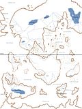
For some reason recently in my creative challenges and work shop stuff I've been revolving around this whole Dark Queen's Empire idea, so during one of my character challenges I had no idea how to describe her location so I just decided to come up with a really rough map of her world in about two hours. Also, I know that the abbreviation is supposed to be DQE, not DQR but I'm too lazy to erase, radda radda. I also tried to fill in land masses and water with colors but paint is evil and won't let me do the color dump correctly. ;__; Just know if it has blue lines/text within it or above/below it, it's a land-mass.
Political Map:

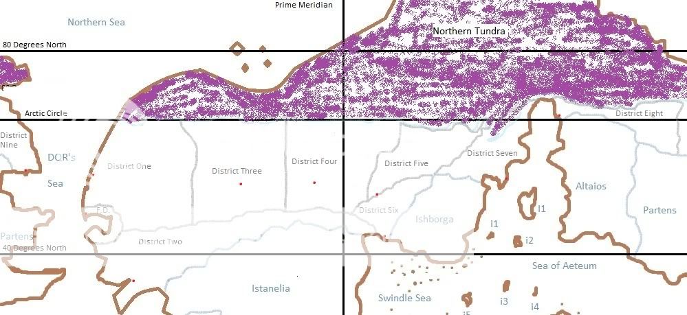
Environmental Map:
(Currently being Reconstructed. Have to re-learn some geology stuff. x__x)
Bodies of Water Map (Please note that the rivers, lakes and seas pictured are only the largest/most significant ones.)
Map Legend:
Political Map:
Brown lines = separation between land mass and water
White within the brown shapes = continents or islands
Light blue lines = political borders
Light blue names = political entities
Black names/Purple color = uninhabited
Environmental Map Color Codes:
Land:
Purple: Tundra
Dark Blue: Taiga
Dark Green: Temperate Deciduous Forest/Temperate Rainforest/Subtropical Forest
Light Green: Prairie (Temperate Grassland)
Orange: Savanna (Sub-tropical/Tropical grassland)
Light-blue: Rainforest (tropical)
Tan/Sand: Chaparral
Yellow: Desert
Seas/Oceans Notes:
Red line: Major current that is warmer than 15 degrees Celsius (59 degrees Fahrenheit)
Purple line: Major current that is between 15 degrees Celsius and 7.5 degrees Celsius (59-45.5 degrees celsius)
Blue line: Major current that is cooler than 7.5 degrees Celsius but not frozen (45.5 degrees Fahrenheit)
Continents and Their Countries:
· Luthena: DQR, Ishborga, Altaios, Partens, Istanelia, Frontanelia, Arthemex, Versalon
· Calropa: Tropos, Lyria, Kingdom of Arxa, Kingdom of Ixfarra, Istaira, Republic of Astr, Composina
· Aestora: Kingdom of Arsea
· Draconia: Drocanian Empire
· Ysira: North Hansr, South Hansr
· Asara: Oscarza
· Efama: Southern Tundra
Lower Case I = Somewhat important Islands:
1.Aeser (Controlled by Ishborga); Trade
2.Altaina (Disputed territory between Ishborga and Altaios); Minor religious site
3.Ättinon (Controlled by Ishborga); Trading
4.Osira (Autonomous State within Ishborga's domain); Precious gems
5.Tekki (Autonomous State within Ishborga's Domain); Minor religious site
6.Afeà (Independent, but in a military alliance with C1); Trading
7.Telokenolos (Controlled by the Kingdom of Arsea); Trading
8.Istrior (Disputed territory between Tropos and the Kingdom of Arsea); Minor religious site
Upper Case I = Important Islands/Island Countries:
1.Ersgarthi = Disputed territory between DRQ, Ishborga and Altaios; major trade center of the north
2.Kingdom of Aria = Independent Kingdom allied with C2; crops and also a center of trade along its southern coast.
3.Isica = An island under the control of the Kingdom of Aria. Supplies crops.
4.Sosgarthi = Independent, though under threat of invasion by the Kingdom of Arxa; major religious site
5.Hanserlanthi = Disputed territory between North Hansr, South Hansr and the Kingdom of Arxa. Precious gems
6.Azelam = Independent. Major trade center between the Kingdom of Arsea, Tropos, Composina, the Kingdom of Ixfarra, and the Drocanian Empire.
7.Yusosgarthi = Once independent but under siege by the Drocanian empire. Home to a major religious site.
Upper Case C = United Set of City States
1.City States of the Aeribbean Peninsula = Unified by a military alliance and economically through use of the same currency.
2.City States of the Osethran peninsula = Unified by a military alliance only. Under threat of being conquered by Lyria.
3.City States of Aðem (Adhem): Unified by a military alliance and economic alliance through the use of a non-tolling system for fellow city states as well as the same currency. Currently free from threat of invasion.
Political Map:

Environmental Map:
(Currently being Reconstructed. Have to re-learn some geology stuff. x__x)
Bodies of Water Map (Please note that the rivers, lakes and seas pictured are only the largest/most significant ones.)

Map Legend:
Political Map:
Brown lines = separation between land mass and water
White within the brown shapes = continents or islands
Light blue lines = political borders
Light blue names = political entities
Black names/Purple color = uninhabited
Environmental Map Color Codes:
Land:
Purple: Tundra
Dark Blue: Taiga
Dark Green: Temperate Deciduous Forest/Temperate Rainforest/Subtropical Forest
Light Green: Prairie (Temperate Grassland)
Orange: Savanna (Sub-tropical/Tropical grassland)
Light-blue: Rainforest (tropical)
Tan/Sand: Chaparral
Yellow: Desert
Seas/Oceans Notes:
Red line: Major current that is warmer than 15 degrees Celsius (59 degrees Fahrenheit)
Purple line: Major current that is between 15 degrees Celsius and 7.5 degrees Celsius (59-45.5 degrees celsius)
Blue line: Major current that is cooler than 7.5 degrees Celsius but not frozen (45.5 degrees Fahrenheit)
Continents and Their Countries:
· Luthena: DQR, Ishborga, Altaios, Partens, Istanelia, Frontanelia, Arthemex, Versalon
· Calropa: Tropos, Lyria, Kingdom of Arxa, Kingdom of Ixfarra, Istaira, Republic of Astr, Composina
· Aestora: Kingdom of Arsea
· Draconia: Drocanian Empire
· Ysira: North Hansr, South Hansr
· Asara: Oscarza
· Efama: Southern Tundra
Lower Case I = Somewhat important Islands:
1.Aeser (Controlled by Ishborga); Trade
2.Altaina (Disputed territory between Ishborga and Altaios); Minor religious site
3.Ättinon (Controlled by Ishborga); Trading
4.Osira (Autonomous State within Ishborga's domain); Precious gems
5.Tekki (Autonomous State within Ishborga's Domain); Minor religious site
6.Afeà (Independent, but in a military alliance with C1); Trading
7.Telokenolos (Controlled by the Kingdom of Arsea); Trading
8.Istrior (Disputed territory between Tropos and the Kingdom of Arsea); Minor religious site
Upper Case I = Important Islands/Island Countries:
1.Ersgarthi = Disputed territory between DRQ, Ishborga and Altaios; major trade center of the north
2.Kingdom of Aria = Independent Kingdom allied with C2; crops and also a center of trade along its southern coast.
3.Isica = An island under the control of the Kingdom of Aria. Supplies crops.
4.Sosgarthi = Independent, though under threat of invasion by the Kingdom of Arxa; major religious site
5.Hanserlanthi = Disputed territory between North Hansr, South Hansr and the Kingdom of Arxa. Precious gems
6.Azelam = Independent. Major trade center between the Kingdom of Arsea, Tropos, Composina, the Kingdom of Ixfarra, and the Drocanian Empire.
7.Yusosgarthi = Once independent but under siege by the Drocanian empire. Home to a major religious site.
Upper Case C = United Set of City States
1.City States of the Aeribbean Peninsula = Unified by a military alliance and economically through use of the same currency.
2.City States of the Osethran peninsula = Unified by a military alliance only. Under threat of being conquered by Lyria.
3.City States of Aðem (Adhem): Unified by a military alliance and economic alliance through the use of a non-tolling system for fellow city states as well as the same currency. Currently free from threat of invasion.