Acquariana's Home-Region: The Northern Middle Sea
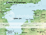 Approximate Coordinates: 32 to 58 Degrees North, 67 to 100 Degrees East
This area of the world consists of the most relatively developed countries on Aqua. Separated by forests, hills, and the shallow sea, many cultures developed. As they gained the ability to sail, they intermixed, assimilating and conflicting to produce this current patchwork of nations. Though some like the Empire of Greysinger have existed as political entities for several hundred years, the Republic of Aquaria is a rather recent development.
Land Legend:
Green = Low elevation
Yellow = Medium elevation
Red = High elevation
Blue = A body of water
Blue line = River
Shapes:
Grass = Grassland
Cotton-like Tree = Temperate Forest
Three Mounds = Hills
Black Dot = City of Importance
Political Legend:
Solid Black Line = Border between countries (Do note that a river forms the rest of the border between the Kingdom of Telaira and Finithia.)
Dashed Black Line = Furthest extent of maritime authority
Numbers: Used to mark places of dispute
1: Vithey: This troubled land is the converging point for several cultures, and as such has been tossed back and forth between Visgarth, the Empire of Greysinger, and the Duchy of Srenia over the years. There appear to be signs of nationalism emerging among the intelligentsia of its largest city, Ivorine, but otherwise, the populace remains divided by ethnic and cultural conflict.
2: Sevärmi Tsemleyista (Northern Land): Though it has a relatively low population, and no major cities, its interest to the nations of Visgarth and the Duchy of Srenia is its rich mineral deposits. There are not many locals, with most of them in isolated villages that dot the northern coast. Though vaguely related to Srenia in terms of language and culture, they do not identify with Srenia or Visgarth. Scholars speculate that if this area were to gain an influential leader, it would be one of the first, if not the first territories to create a state based upon nationalism.
-----------------------------------------------------------------------------------------------------------------------
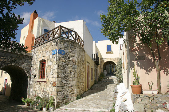
Acquariana's Home-town: Tireste
Source
Coordinates: 34.29 Degrees North, 71.55 East
Population: Approximately 15,000 People
Area: 400 square kilometers (154.4 square miles)
Name: The name of the town is Tireste. (IPA: English: [tɪˈrɛst] Aquarian: [tiˈɾeste]) The name is derived from the ancient pre-Actaenian name Tergeste, itself an Aectinization of the extinct local language's name for the town, Tergest, meaning market place.
Geography: The village sits on a slightly elevated area facing the northern waters of Delfi Bay. On the southern end of the town is the village's administrative buildings, church, and port. As one travels northward, the elevation begins to increase, since the village is built into a rather large, but low hill. Half a kilometer or so north from the port is the main piassa (square), where goods are sold. On the northern end at the top of the hill lie several large estates overlooking the village. Just a few miles to the southwest of the village is its main water source, the Attinean River, the confluence of two major rivers that stretch well outside of the Republic. To the northwest and north are grasslands, farms and low-rising hills. Northeast of the city lies chaparral.
Climate: Tireste has a warm Mediterranean climate. During the summer, rain is rare and temperatures often exceed 30 degrees Celsius (86 Fahrenheit) during the day. The heat can become particularly unpleasant due to increasing humidity measurements up to 80%. Summer in Tireste lasts from late April to mid-October. Fall is a brief, generally pleasant transitional season lasting from mid-October to mid-December. Highs range descend from around 24 Celsius to 18 Celsius in this time-frame (75.2 to 64.4 Fahrenheit). The influx of cooler air by the jet stream mixing with the warm air and sea currents helps produce precipitation that continues into late March. A large mass of land extending to the west and its hills somewhat mitigate the effect of the two conflicting air masses, ensuring that the winter is not too cold or stormy. Average maximum temperatures in January and February are approximately 17 degrees Celsius (62.2 Fahrenheit), though they can vary anywhere from 15 to 19 degrees Celsius (59 Fahrenheit to 66.2 Fahrenheit) depending on the movement of the jet stream. Lows during this time never fall below 7 degrees Celsius (44.6 Fahrenheit), making snow a near impossibility. The end of "Winter" is marked by the blooming of the Aquabell in mid-March, a member of the lily family with light, blue-green colored flowers that resemble a bell. March and most of April serve as a transitioning "Spring" to Summer, with increasing sunlight and rising temperatures, although slightly cooler than Fall.